
When Apple Maps first launched in 2012, things didn’t go well. Apple had to work quickly to solve the numerous flaws and glitches in the initial releases. However, the software has developed into a strong and practical tool in the years that have passed. Numerous elements in Apple Maps can assist you in getting where you’re going whether you’re driving, walking, biking, or taking public transportation.
The Maps app adds new features every time it is updated to make traveling easier. To benefit from the most recent and advanced enhancements, you must install iPadOS 18 or iOS 18. Here are 18 advantages of using Apple Maps instead of Google Maps.
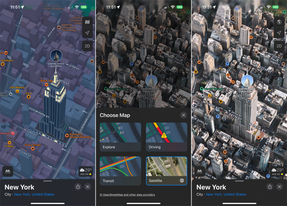
See 3D Cities
When you can explore a city in three dimensions, with street names, buildings, landmarks, and other characteristics, why limit yourself to two dimensions? Look for a big metropolis, like New York, Los Angeles, Paris, Rome, or Tokyo, to start the 3D mode. When the 3D icon shows up in the upper-right mini toolbar, tap it. And then a 3D rendering of the city. To view the city in full color and three dimensions, select Satellite mode by tapping the Map button located at the top of the small toolbar.
Obtain Real-Time Transportation Data
For the most recent transit information on buses, trains, and ferries when using public transportation, check Apple Maps. Once you’ve done a directions search, press the train icon to view your options for local public transit, along with information about which line to take, where to board, and whether there are any delays. Even more, you may select your preferred transit routes and get alerts when it’s time to get off at the next stop.
Look Up Nearby Locations
Maps provides you with a list of businesses and other places you might wish to visit when you use the Search tool. In this method, you can locate nearby dining establishments, petrol stations, coffee shops, supermarkets, lodging facilities, pubs, and medical facilities.
Examine Your Environment You
Look Around is an interactive 360-degree view of a location that is similar to Google Street View. Use it to check out your destination before you arrive. Swipe up on the screen and tap the thumbnail photo in the lower-left corner of the screen when you’re in an area that supports the function. After then, you can explore the area, zoom in and out, or move quickly. To view the map and Look Around mode simultaneously, tap the double arrow icon in the upper left corner or the binoculars icon in the lower left corner.
Try using Flyover Mode
Use Flyover to see a certain city from above. In the search bar, enter the name of a supported city, such as Tokyo, New York City, Paris, London, or Florence. To see the city from above, use the Flyover button on the place card. Next, you may control zoom by pinching in or out and moving your phone or swiping the screen to move around. To go on an automatic tour of the city, tap Start Tour.
Take a Bicycle Riding
You can use bicycle routes to find your way to a destination with Apple Maps. Select your destination and press the icon for the bicycle. The directions will indicate how to get there if your location is bike-able. You may also find out from the app whether the path is steep or downhill. You may even find directions on a real bike track in some places. Press the Go button to start your journey.
Take a Hike
You can locate and find your way to hiking trails with iOS 18 and iPadOS 18. Enter the name of a certain park, hiking path, or other hiking destination in the Search Maps form. If not, search for “hike” or “trails” to find out which ones come up. To get more information, select a specific area and scroll down the screen. If there’s a Trails section, click on it to see hiking instructions. After that, you can download the directions to use offline.